

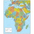
Africa Wall Map GeoPolitical Edition by Swiftmaps (18x22 Laminated)
Details
- Color18x22
- BrandSwiftmaps
- Map TypePhysical
- Paper FinishCoated
- Sheet Size18 x 22 Inches
Description
🌍 Elevate your space with knowledge and style!
- ANNUAL UPDATES - Stay current with the latest political boundaries.
- DURABLE DESIGN - Laminated for longevity and resilience.
- DUAL FUNCTIONALITY - Explore both political and physical landscapes!
- RISK FREE PURCHASE - Full refund guarantee for peace of mind.
- EDUCATIONAL DECORATIVE - Perfect for classrooms or stylish offices.
The Africa Wall Map GeoPolitical Edition by Swiftmaps is a versatile 18x22 laminated map that combines essential political data with a stunning 3D physical relief layer. Designed for durability and updated annually, it serves as both an educational tool and a decorative piece, ensuring you stay informed and stylish in any setting.
Specifications
| Paper Finish | Coated |
| Color | 18x22 Laminated |
| Item Dimensions L x W | 22"L x 18"W |
| Paper Size | 18 x 22 Inches |
Have a Question? See What Others Asked
Reviews
J**N
Teaching
Great piece for teaching.
B**U
Detailed and colorful
Great for hanging on a home wall. We used it in a display with photos taken in Africa. Certainly good for home schoolers but might be a little small for large classrooms.
W**S
Map
Loved this product thank you for the timely delivery
K**B
Great in the Classroom
Wanted a set of continent maps for the classroom and the Swiftmaps ones are the only ones I liked.
K**Y
Mapit
Great map
E**N
Large and Colorful
This map met my expectations. Only issue was trying to flatten it out to post on my wall. Yes, it doesn’t include every single city or island nation. But who cares! This is a GEOGRAPHICAL map, not a political map. If this map had zoomed out to include the two missing island states, then you’d have a much smaller view of the African land mass. One of the comments I found most comical was someone complaining about the inaccuracy of a tiny European country. Europe is not the focus of the map! Europe is just there, sitting in the way in order to showcase Africa. I swear that some people are just trolling. And so what if the map didn’t include the latest country name change by the dictator of Swaziland. I’m satisfied with the map. It’s simple and basic.
B**E
Product quality
It’s all good.
J**S
Good Product
Just what I wanted.
Common Questions
Trustpilot
2 months ago
4 days ago
